
Whenever you live near someone for a significant period of time, you get to know them and understand them. Eventually, you may find that you have common interests or beliefs and can work together to affect change in your neighborhood such as creating a neighborhood watch group.
This type of situation may have also taken place in Harrisburg in the early 20th century with members of the Harrisburg League for Municipal Improvements. Several weeks ago, our Digital History class took a trip to the Dauphin County Historical Society. There I was able to obtain a list of Municipal League members between 1902 and 1905. This data was put into a Microsoft Excel spreadsheet and Professor David Pettegrew helped georeference the individual addresses for the residences of members on a 1900 map of Harrisburg. The end result is shown below. Each dot represents where a member of the league lived.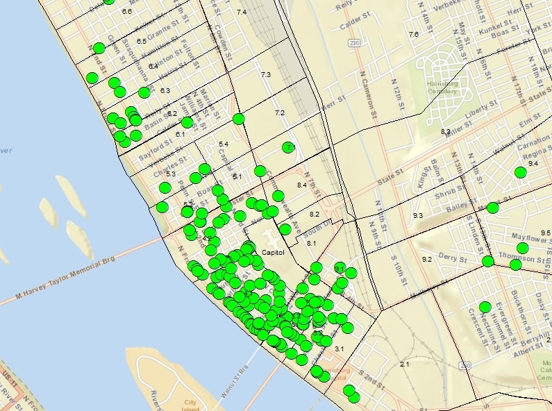
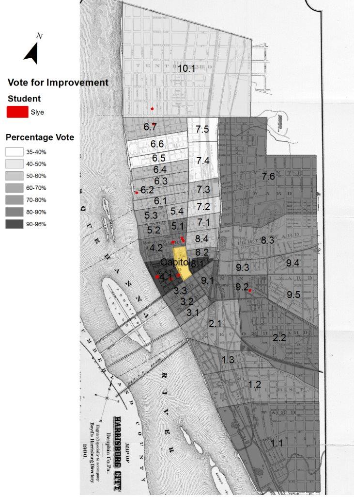
What is most notable about the map is that it shows significant clustering of members in the 4th and 3rd wards. Looking back at a map (shown below) from a previous post, titled The City Votes: Spatial Influences of the Reformers, it is clear that the 4th and 3rd wards also showed the most support for the Campaign for Improvements. Moreover, many of the league members lived near the capitol, mostly likely because many were politicians or had political connections. In fact, our Digital History class is currently working on a story map project. In this project, I chose 10 prominent Municipal League members and will be analyzing and researching where they lived and who they were. Initially, it seems the locations of the 10 members are proportional to the locations of all of the other members. In other words, the locations of the 10 members shows the same patterns as the map of the residences above, but on a much smaller scale. More importantly, however, almost half of them were, at one time, mayor of Harrisburg.
While there are some outliers in the larger map of the members, such as the smaller groups of members in the 6th ward, and no conclusions are certain, we can infer a few things. For example, the close proximity in which the members lived may have led to the creation and support of the Municipal League because they experienced things they wished to change about the city. Having recognized these problems and talked to their neighbors about them over sports or other social events, which many in my sample of 10 members were involved in, they could have decided to come together to create this change. Their confidence could stem from the fact that many were involved in politics or at least lived near the capitol where they could lobby their views.
This would explain the more political nature by which the Municipal League operated. For instance, according to Paul Beers in his book City Contented, City Discontented, the same day that Vance McCormick ran for mayor he added the “bond issue” to the ballot (31). This bond issue would use tax revenue to pay for improvements to the city. Once citizens voted in favor of the bond, the Municipal League was responsible for hiring consultants to help fix problems like water filtration. Yet, the bond issue was only put on the ballot nine months after the league had formed (Beers, 31). This shows how quickly the league turned to politics to enact change in Harrisburg.
To conclude, although one should be cautious about drawing conclusions from the data, there is something to be said about the spatial interactions of the Municipal League members. The majority of the members lived in clusters in the 3rd and 4th wards near the capitol. These areas showed the most support for improvements to the city. This may point to the nature of how the league was formed andoperated, and who comprised it.

One thought on “Harrisburg League for Municipal Improvements: Spatial Perspectives”