
As a Public History major, I have been bestowed the honor of continuing the work that Rachel Petroziello had started last semester on the Lincoln Cemetery Mapping Project. For some context, Lincoln Cemetery is a historically Black cemetery in Penbrook, Pennsylvania, which is also an eternal resting place for some historically significant figures such as the first Black war reporter Thomas Morris Chester. However, it has become abandoned and forgotten over time only until recent restoration efforts breathe life into them.
What I hope to achieve this semester is to complete data collection on the gravestones and create an initial interactive map for the public on the ArcGIS Field Maps mobile app. I first stepped foot in Lincoln Cemetery for data collection with Dr. David Pettegrew on Tuesday afternoon of 28th February 2023. It was my first time laying my eyes on the actual site, and the first thought that emerged was that the estate appeared cleaner and more well-kept than I expected, which I quickly realized was thanks to the continuing efforts of the grassroots group SOAL (Saving Our Ancestors’ Legacy) that allowed sunshine to pour through these neglected burial grounds.

First meeting with Professor Albert Sarvis from Harrisburg University. He was sharing knowledge on the technical side of the project and discussing the details of the collaboration with Dr. Pettegrew.
Aside from Dr. Pettegrew and his son, I was also meeting with one of our collaborators, Professor Albert Sarvis from Harrisburg University of Science and Technology. Our geospatial collaborators at the Center for Applied Environmental & Geospatial Technology, Harrisburg University has been developing a mobile app on the ArcGIS Field Maps to set up for field collection. With a kind smile and much patience, he demonstrated to us how to use the ArcGIS Field Maps app for data collection, which was our primary goal today— to test-run the mobile app for capturing data on-site in terms of location accuracy and efficiency. While out in the field, users can take photos of the stones, add points, and remove points. Soon enough, the smile on Professor Sarvis’ face soon made its way to both Dr. Pettegrew’s and mine as we realized how easy and efficient it is to use the app to record data.

Trial running the mobile app for the first time. One of the main features we were concerned about is taking a picture of the gravestone and uploading it to the system so that I will be able to complete the information on the backend.
Throughout the process, we found that the accuracy of points (between actual stone and points on the digital map) was slightly off by a few centimeters—a problem we can easily resolve through the app by editing the point. We also realized the interface of the map on the app has to be more user-friendly and easily understood. I suggested we should continue to work towards a direct and focused interactive map solely showing the cemetery to avoid confusion on the viewer’s part. One of the other ways to improve the ease of navigation for viewers is to visually divide the cemetery grounds into a few sections on the map with clear numbers/labels.

Example of an aerial view of the cemetery, with red circles on the map indicating existing stone locations. The aerial photographs were captured through a drone survey by a team from Harrisburg University of Science and Technology in September and November 2022 (see this post)
Aside from that, a few current updates were needed for the app such as increasing the maximum number of names to be entered as we discovered multiple stones that exceeded the initial limit of 6 names (found some with 7 names). Another was to change the color of the points after it has been edited to avoid duplication as it will be clear to the field collector which ones needed to be edited and which ones are completed. In terms of time consumption, it took a person about 40 minutes to record 6 stones, which in my opinion is quite decent, considering the fact that we will have a bunch of helping hands afterward to cover the area in a more efficient manner.

Professor Sarvis and I inspecting a gravestone’s inscriptions while test-running ArcGIS Field Maps mobile app on our phones. We were attempting to discern how far off the location of the stone was from the points on the map as we realized the map-stone location accuracy was not perfect.
As we plan to bring a bigger group of people to the cemetery during in-service day for group collection, I thought it would be helpful to outline how to use the ArcGIS Field Map (Mobile App) for data collection at the cemetery:
Procedure

① First, select “Lincoln Cemetery Field Map Editing” under Maps once the app opens up. It will then show an aerial view of the cemetery, along with red circles indicating existing stone locations. The aerial map will take some time to load so do not be alarmed if it appears blank for a few minutes. Then tap on whichever stone you wish to edit.
② To ensure you have chosen the stone desired correctly, a cyan light blue circle will light up in place of the initial red circle you have tapped on. The FID and SID of the stone, which are system-managed values that uniquely identify a record, will also appear. On the left bottom corner, tap on the pencil icon to edit the information about the selected stone.
③ After having selected the edit function, a circle will enclose the area, with the center target sign set on the selected spot. On the bottom left corner, tap on the camera icon to take a picture of the stone.
④ The screen will then transition into a camera to allow you to take a picture. If you are satisfied with the photo, tap on “Use Photo” in the bottom right corner. If a retake is needed, tap on “Retake” in the bottom left corner.
⑤ After a satisfactory photo is chosen, the screen will jump back to the editing interface. Pull up the bottom screen to fill in or edit information in prepared blanks such as First Name, Last Name, Date of Birth, Date of Death, First Name, Last Name, Stone Type etc.
⑥ After all relevant information is completed, tap on the blue button “Update Point” to save the data. A small window will pop up with the text “In Progress…”, which indicates completion and successful save of information.
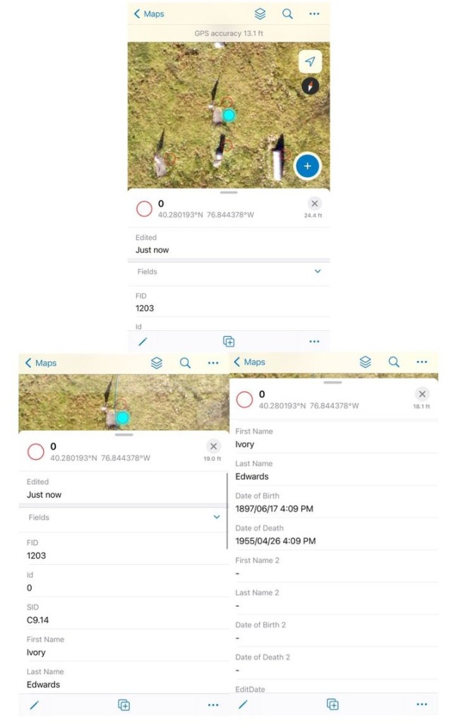
This is how it will look after the editing is done. Under the row “Edited”, a timestamp of when the data is edited will appear to keep track of when it was last modified. By pulling up the bottom tab, viewers can access basic information about the person or people buried under the stone which has been filled in.

Professor Sarvis and Dr. Pettegrew discussing the logistics of the project at the cemetery.
The field experience also opened my eyes to things we need to look out for in order for the group trip to maximize its purpose:
- Sufficient phone battery and charging spot. This came to my attention due to my own phone’s dying almost halfway through the visit (this does not mean that Field Maps consume an insane amount of battery; my phone battery was already low before the trip). In fact, the screenshots of the procedure were the very last moments my phone saw before succumbing to death. But since we would most likely be staying on-site for more hours during the group trip, I figured a portable charging port would be ideal. When I mentioned this, Professor Sarvis resourcefully offered to provide a huge power bank that could charge up to 40 phones.
- Protective shoes as there are still litter and unexpected objects around as well as uneven ground.
- Division poles to mark and divide the area so it’s easier to identify and delegate work according to the split area.
- Rakes and cleaning tools to part/clean up the stones so as to have a clear view of the stone and its inscriptions as there may be objects blocking the view. Evident in the image numbered 4 under Process (above), some of the inscriptions were concealed because of overgrown grass covering part of the stone: a retake of the picture was needed and made afterward.
- Suggestion to work in pairs to ensure efficient work and avoid mistakes.

The remaining sun rays of the day leaked through the old trees as I turned to look at the cemetery beside the gate, satisfied and ready to leave. But beyond that, I was even eager to return once more. Having the opportunity to walk through the final resting place of these people who were part of an unknown history, waiting to be unraveled and to spread beyond the small cemetery. The blowing winds seem to whisper unknown stories of the deceased, and now it rests on my shoulders to grasp them and breathe life into their legacies.

Passionate about culture, history, social justice, geography, languages, food, and the intersectionality of all this, WenXin Ling is a double major in Sociology and Anthropology as well as Public History, minoring in Digital Public Humanities at Messiah University.

This was such a joy to read! Knowing th